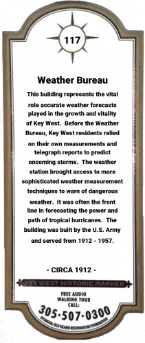
Hear the Key West "Voices of History™" on our Phone Tour (305) 507-0300
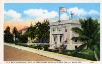
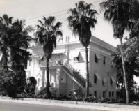
Weather Bureau
CIRCA 1912
Historic Marker number 117 located at 57 Front Street in Truman Annex.Accurate weather forecasts are vital to the growth and success of a community. This building was an integral link in the legacy of the United States Weather Bureau.Without the use of advanced forecasting tools we enjoy today, our ancestors were dependent on a basic history of weather in their area and a couple of rudimentary tools.Research of Key West personal journals shows that many of the daily entries noted the wind and barometric pressure. The preoccupation with any out of the normal climate changes represents some of the challenges of living on a sub-tropical island.In 1832, citizens started recording daily rain amounts at the Key West Lighthouse. While that information added to the overall climate knowledge, it was probably more of a response to the need to collect water from rooftops. Key West's sole source of fresh water was collected and stored in cisterns throughout the historic district in the 1800s.Before the formation of the Weather Bureau, a loose network of forecasting locations was primarily run by local citizens throughout the country. The speed of warnings and information was limited by the speed of a pony express or a sailing ship.That all changed with the invention and widespread use of telegraphs during the 1860-70s. Forecast range and accuracy greatly improved with the connection of land line telegraph services and the first underwater telegraph cable laid between Key West and Cuba in 1867.By 1870, a Joint Congressional Resolution requiring the Secretary of War "to provide for taking meteorological observations at the military stations to make warnings by magnetic telegraph and marine signals, of the approach and force of storms" was introduced. Congress passed the resolution and on February 9, 1870 and President Ulysses S. Grant signed it into law. With that law, a new national weather service had been born within the U.S. Army Signal Service's Division of Telegrams and Reports that would affect the daily lives of most of the citizens of the United States through its forecasts and warnings for years to come.By 1890, the Army Signal Corps had expanded the nation's weather centers to 24 sites and was transferred to the Department of Agriculture as the National Weather Bureau. Key West's first weather service was located at the Army Barracks in Peary Court. Over the years it had numerous locations including the Jefferson Hotel that was lost in the Great Fire of 1886. See Marker #28 for additional information on Key West's worst fire.The building before you was built in 1912 as the United States Weather Bureau on the Fort Zachary Taylor Army Base. In 1947 the base was transferred to the U.S. Navy and was renamed the Truman Annex Navy Base. From 1912 to 1957 it served as a vital link in the National Weather Bureau's network of forecast locations and was often on the front line predicting the path and power of tropical hurricanes. After 1957, the Weather Station building served as residential housing for the U.S. Navy and was subsequently abandoned after the closure of the Base Annex in 1974. The two-story structure, renaissance in style, typifies both the U.S. military architecture of the period and the unique site of a tropical American military base.The building was reopened as the Weather Station Inn in 1977. The current National Weather Bureau building is located at 1315 White Street. See Historic Marker #40 and #97 at the National Weather Bureau building for additional information on historic hurricanes and their effects on Key West.